Phú Thọ province: Hùng Kings temple complex and origin myth
Phú Thọ is home to the Hùng Kings Temple complex, the national origin site of Vietnam, plus UNESCO-listed Xoan singing, tea hills, and pomelo orchards.
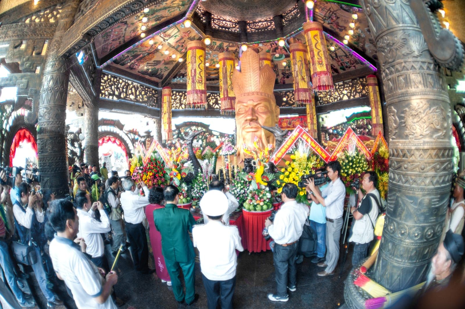
Phú Thọ is a hill province roughly 80 to 100 kilometers northwest of Hanoi, at the point where the Red, Lô, and Đà rivers converge. For most Vietnamese people it holds a status that few other provinces can claim: it is widely regarded as the cradle of the nation, the place where the legendary Hùng Kings are said to have founded the earliest Vietnamese state. The provincial capital, Việt Trì, sits near this convergence of rivers and serves as the practical gateway for visitors heading to the temple complex on Nghĩa Lĩnh mountain.
Beyond the origin myth, Phú Thọ is also known for two UNESCO-recognized cultural markers, Xoan singing and the broader Hùng Kings worship tradition, along with rolling tea plantations and pomelo orchards that supply much of northern Vietnam. This page covers the temple complex, the historical and mythological layers behind it, Xoan singing, the agricultural side of the province, and practical notes for a visit.
The Hùng Kings Temple complex at Nghĩa Lĩnh
The Đền Hùng (Hùng Kings Temple) complex sits on Nghĩa Lĩnh mountain in Việt Trì, about 128 meters above the surrounding plain. It is not a single building but a cluster of temples, gates, and shrines built at different points along a stone staircase that climbs the mountain, including the Lower Temple (Đền Hạ), the Middle Temple (Đền Trung), the Upper Temple (Đền Thượng), and the tomb attributed to the sixth Hùng King. Most of the structures visible today date from the Lê and Nguyễn dynasties, with restoration and expansion continuing into the 20th and 21st centuries, though local tradition holds that a place of worship on this site predates recorded history.
Visitors typically climb several hundred stone steps to reach the upper shrines, and the walk can take 45 minutes to over an hour depending on pace and how many stops are made at each temple level. The complex is set within a forested hillside that also functions as a national historical park, with museum buildings near the base that display Bronze Age artifacts connected to the Hùng era.
The origin myth: Lạc Long Quân, Âu Cơ, and the 18 Hùng Kings
Vietnamese origin legend holds that the dragon lord Lạc Long Quân married Âu Cơ, a mountain fairy, and that she gave birth to 100 eggs, from which 100 sons hatched. The couple is said to have parted ways, with 50 sons following their mother into the mountains and 50 following their father to the sea, and the eldest son becoming the first of the Hùng Kings, founder of the Văn Lang kingdom. Tradition counts 18 Hùng Kings in total, though this figure is generally understood by historians as a symbolic or compressed lineage rather than a literal king list, since some individual reigns would have needed to span improbably long periods to fit the traditional dating.
The Hùng Kings era is conventionally associated with the Bronze Age culture of the Red River Delta, and the archaeological record most closely linked to this period is the Đông Sơn bronze drum tradition. Readers interested in the material evidence behind the legend may want to see the related page on Đông Sơn bronze culture, which covers the drums, tools, and burial goods that provide the closest thing to a historical anchor for the Hùng era.
Hùng Kings' Festival and national commemoration day
The tenth day of the third lunar month, Giỗ Tổ Hùng Vương, is a nationally observed holiday commemorating the Hùng Kings and typically falls in April on the Gregorian calendar. It is one of a small number of public holidays in Vietnam, and in most years it draws large crowds to Đền Hùng from across the country, alongside smaller commemorations at Hùng Kings worship sites and communal houses elsewhere in Vietnam. The belief in and worship of Hùng Kings, as a folk practice extending well beyond the temple complex itself, was inscribed on UNESCO's Representative List of the Intangible Cultural Heritage of Humanity in 2012.
Visitors planning a trip around this date should expect significantly heavier traffic on the approach roads from Hanoi and larger crowds at the temple steps, so arriving early in the day is generally advisable if trying to avoid the busiest hours.
Xoan singing: a UNESCO-listed tradition
Hát Xoan, or Xoan singing, is a form of ritual singing native to Phú Thọ that combines song, dance, and instrumental accompaniment, traditionally performed at communal houses and temples as an offering connected to Hùng Kings worship. It was inscribed on UNESCO's Urgent Safeguarding List in 2011 after the number of practitioners had declined sharply, and was later moved to the Representative List in 2017 following revitalization efforts, including training programs for younger performers in villages around Việt Trì.
Xoan singing shares some family resemblance with other northern Vietnamese folk vocal traditions, such as Quan Họ singing from nearby Bắc Ninh, though the two developed in different social contexts and are not the same repertoire. Visitors with a general interest in Vietnam's UNESCO-listed folk singing traditions may find useful background on the related Quan Họ and Ca Trù page, which covers how these traditions are structured and where performances can typically be seen.
Tea hills and pomelo orchards
Away from the temple complex, Phú Thọ's economy leans heavily on agriculture, and tea is one of its signature crops. The province's mid-elevation hills, particularly around Thanh Sơn and Tân Sơn districts, support tea plantations that have supplied both domestic and export markets for decades, and some tea cooperatives in the area offer informal visits to see processing in person, though these are generally less set up for tourism than the tea regions further north or in the central highlands.
Phú Thọ is also known for pomelo, most famously the Đoan Hùng pomelo variety grown in the district of the same name, prized locally for its thin skin and sweet, low-acid flesh. The pomelo harvest generally runs in the autumn months, and roadside stalls along routes into the province commonly sell the fruit in season. Readers curious about how Đoan Hùng pomelo compares to other regional fruit varieties can find broader context on the Vietnamese fruits page.
Getting to Phú Thọ from Hanoi
Phú Thọ is a manageable day trip or overnight stop from Hanoi. By road, the drive to Việt Trì typically takes around two hours depending on traffic and route, and buses running from Hanoi's My Dinh station also serve Việt Trì on a regular schedule. Some visitors combine a stop at Đền Hùng with a longer loop toward Tuyên Quang or Yên Bái, since Phú Thọ sits on natural routes heading northwest out of the Red River Delta.
There is no major international airport in the province, so most travelers arrive via Hanoi's Nội Bài International Airport and continue overland. Confirm current bus schedules and driving times directly with a transport operator before finalizing plans, since routes and frequency can change.
Practical visiting notes
The temple complex is generally open for visits year-round, though the climb up Nghĩa Lĩnh mountain involves uneven stone steps that may be uncomfortable for visitors with mobility limitations, and comfortable footwear is advisable. Modest dress is appropriate given the site's religious significance, similar to expectations at other major Vietnamese temple and pagoda sites. Weekdays outside the Giỗ Tổ Hùng Vương holiday period tend to be considerably quieter than weekends or the festival window itself.
Facilities near the base of the mountain typically include parking, small food vendors, and a museum, though options thin out closer to the upper temples, so bringing water for the climb is a reasonable precaution, particularly in the hotter months.
Vĩnh Phúc
Vĩnh Phúc, immediately northwest of Hanoi and wedged against the Red River delta, is now part of Phú Thọ province, known chiefly for altitude and cool air within easy reach of the capital rather than for any single monument. Its main draw is Tam Đảo, a former French hill station developed in the early 1900s at roughly 900–1000 meters elevation, several degrees cooler than the delta and prone to thick mist settling over the ridge for hours at a time. Little of the original French townscape survives beyond a handful of ruins, most notably the roofless stone shell of a former church, Nhà Thờ Đá, now one of the town's most photographed spots. The present-day town is a compact strip of hotels, restaurants, and a small market, with Thác Bạc (Silver Waterfall) a short walk away and Tam Đảo National Park extending into the surrounding forest.
At the base of the same mountain range sits Tây Thiên, a cluster of pagodas and shrines connected partly by cable car and partly by a fairly demanding stone stairway climb. The site blends Buddhist temples with older folk-religion shrines to a local mother goddess figure (Đạo Mẫu); claims that it was an early center of Buddhism in Vietnam are contested and best treated as tradition rather than fact. Its main pilgrimage season falls in the early lunar new year months, when crowds and cable-car queues can be considerable; outside that window the complex is markedly quieter.
Đại Lải Lake, an artificial reservoir near Phúc Yên, is closer to Hanoi and reachable without the mountain road, often under 90 minutes by car. Since the 2000s its shore has been developed with resorts, villas, and at least one golf course aimed at Hanoi weekenders, offering boating and pool time rather than culture or scenery. Tam Đảo itself is roughly 65–70 km from central Hanoi, about two to two and a half hours by car with switchbacks on the final climb; Tây Thiên adds only a modest detour if paired with it. Shoulder-season spring and autumn are generally the most comfortable months for the hill station; summer weekends draw the biggest crowds of Hanoi residents escaping the heat, and winter can turn cold, damp, and wet with persistent low cloud.
Hòa Bình
Hòa Bình, the mountainous stretch roughly 70–100 km southwest of Hanoi where the Red River delta gives way to limestone hills, is now folded into Phú Thọ province and is best known as the ancestral home of the Mường people, Vietnam's second-largest ethnic minority, and for the prehistoric stone-tool tradition that takes its name. The Đà (Black) River has been dammed here to form the Hòa Bình Reservoir, a narrow lake roughly 200 km long reaching toward Sơn La, and most visitors experience the area through the reservoir, the Mai Châu valley, or the road corridor toward the northwest mountains.
Mai Châu is the best-known destination within it, a valley ringed by limestone karst and dotted with stilt-house villages of the White Thai community. Lác and Pom Coọng villages have run homestays for roughly three decades, family-run rather than agency-run, with cycling on the flat paddy circuit, an evening Thai dance performance, and a Sunday-morning Hmong market at Pà Cò, about 30 km into the hills.
Away from Mai Châu, the rest of the area is predominantly Mường, a group linguistically close to the Kinh majority, living in stilt houses with their own weaving patterns, gong-music traditions (cồng chiêng), and folk epics such as "Đẻ đất đẻ nước." These sites are less packaged for tourism and generally need a local guide or homestay connection. In the 1920s, French researcher Madeleine Colani excavated cave sites here and identified a flaked stone-tool tradition now called the Hoabinhian, a term used across Southeast Asian prehistory from southern China to Indonesia; few caves are set up for casual visitors, so this is mostly background interest unless arranged through a specialist guide or the provincial museum.
The Hòa Bình Hydroelectric Plant, built in stages through the 1990s with Soviet engineering assistance, was for years the largest hydropower facility in Southeast Asia and still feeds the national grid. The reservoir it created is a modest boating and freshwater-fish destination, with lakeside restaurants and boat tours from jetties near the city. Local food includes cơm lam (rice steamed in bamboo tubes), grilled river fish from the reservoir, foraged forest greens, and rượu cần (jar rice wine drunk through bamboo straws) at homestay dinners. Hòa Bình City is roughly two to two and a half hours from Hanoi by car or bus; there is no airport or rail line, so road is the only option.
Related
Frequently asked questions
What is the Hùng Kings Temple complex?
How many Hùng Kings were there?
What is Xoan singing and why is it significant?
When is the best time to visit Đền Hùng?
How do I get from Hanoi to Phú Thọ?
Continue reading
Comments
No comments yet.